Research Article - (2026) Volume 13, Issue 1
Received: 22-Feb-2026, Manuscript No. AJOEE-26-185507; Editor assigned: 25-Feb-2026, Pre QC No. AJOEE-26-185507 (PQ); Reviewed: 11-Mar-2026, QC No. AJOEE-26-185507; Revised: 20-Mar-2026, Manuscript No. AJOEE-26-185507 (R); Published: 27-Mar-2026
The study assessed Landuse and Land Cover Change (LULCC), vegetation diversity and sustainable conservation and in the mangrove area of Akwa Ibom state, Nigeria. The study specifically mapped and assessed the patterns of landuse change within the period of thirty-six years (1986 to 2022), investigated the drivers of landuse change, assessed the current status of vegetation diversity, examined the effect of landuse drivers on vegetation diversity, and project the future land cover for conservation and sustainability in the area. To achieve these objectives, the study used remotely sensed image data, and direct field observation. Landsat imageries of 1986, 2003, and 2022 were utilized for pre-processing using unsupervised classification; questionnaire were used to determine the drivers of landuse practices; direct field study to examine the current vegetation status in the area. Result revealed that open water decreased by 1.17% with a 0.017 sq.km annual rate of change, while mangrove swamp forest witnessed a fluctuating fortune as there increased at 37.87% with annual rate of change of 0. 035 sq.km for the periods (1986-2003), while the periods (2003 to 2022), witnessed a margunal decrease of 20.98%. Also, a 34% decrease was observed for the fresh water swamp forest with a 0.494 sq.km rate of annual change, while builtup/bareland increased at 12.52% and 33.7% at an annual rate of 0.798 sq.km and 0.49 sq.km respectively. The study recommends an urgent need for collaborative (that is community leaders, family heads, and government) land management through designing relevant framework to mitigate measures and adopt the concept of sustainable development in the study area.
Landuse and Land Cover (LULC) changes are considered as one of the most significant components of the terrestrial environment system and one of the main challenges affecting the natural landscape at the local, national and global levels. The main causes of land change have been associated to anthropogenic factors such as fires, territory fragmentation, agricultural (intensification of agriculture), livestock, buildings, infrastructure, deforestation, urbanization, mining industry (Moncreift et al., 2021). In recent decades, scientists have emphasized the importance of incorporating LULC change studies in investigating climate change since it is evident that climate can affect and be affected by changes in the condition and composition of LULC (Bosire et al., 2019). These changes, thus, intrinsically modify the sustainability of different biophysical resources including water, vegetation, forests, soil and agricultural resources. Consequently, landuse changes have been associated with increasing demand for agriculture, livestock grazing and settlement which have been identified as the main causes of wetland degradation (Wang et al., (2023). Remote sensing and GIS techniques have immense potential in determining and assessing the spatial variability of the LULC. Systematic mapping of species occurrence in a given area provides distributional pattern related to ecological parameters and their quantum of availability. Identification of rare, endangered and threatened species is essential for prioritization of conservation in the area (Thakur et al., 2020). Classification in remote sensing involves clustering the pixels of an image to a (relatively small) set of classes, such that pixels in the same class are having similar properties. The majority of image classification is based on the detection of the spectral response patterns of land cover classes.
Mangroves are critical habitat for many species of fish and wildlife, serve as coastal fish and shellfish nursery habitat, and produce large quantities of leaf material that becomes the basis for a detritus food web (Haj, 2023). Despite the importance of mangrove vegetations, they are threatened all over the world by direct and indirect causes by factors stretching across global climate change with its effects such as rising of temperature, sea level, atmospheric CO2 etc. with decline in anthropogenic activities (Sasmito et al., 2020).
As the United Nations (UN) Decade of Ecosystem Restoration (2021-2030) approaches, mangrove ecosystem health and productivity must be a part of global efforts to eradicate poverty, strengthen food security and reduce vulnerability to adverse effects of climate change. Consequently, research interest geared towards the sustainable conservation and management of mangrove ecosystem is at the frontiers of contemporary global discourse.
Despite the negative effects of anthropogenic activities on land cover, there is continuous destruction of land covers in Akwa-Ibom state (Olowokudejo, 2018). By building upon this existing knowledge, the present study aims to contribute to the understanding of land cover changes in the mangrove ecosystem of Nigeria, specifically focusing on the detection and monitoring of these changes using remote sensing and GIS techniques with a view to monitoring and controlling this landuse changes, especially those caused by human activities.
Objectives
• Map and characterize the Mangrove Ecosystem of Akwa Ibom state.
• Establish the landuse and land cover activities within the mangrove area of Akwa-Ibom for the period 1986 to 2022.
Land cover classification has recently been a hot research topic for a variety of applications. Sleeter, (2019) defined change detection as the process of determining and/or describing LULC changes at different times using remote sensing techniques. Eventually, it involves the ability to quantify the temporal effects using multi-temporal data sets. Jian et al., (2022) on the other hand agreed with above researchers as they opine that change detection involves quantitatively identifying the differences between multi-temporal data sets to see the dynamics of the phenomena of interest. Landuse affects land cover and changes in land cover affect landuse. A change in one however is not necessarily the product of the other. Changes in land cover by landuse do not necessarily imply degradation of the land. However, many shifting landuse patterns driven by a variety of social causes, result in land cover changes that affect biodiversity, water and radiation budgets, trace gas emissions and other processes that come together to affect climate and biosphere (Luo et al., 2022).
Explaining the relationship between LULCC and mangrove depletion Rull et al., (2022) emphasized the importance of change analysis methods in detecting and managing mangrove ecosystems. They used NDVI change analysis and land cover/landuse change analysis derived from time series satellite images to estimate the change rate and develop conservation management strategies. In the same vein, Sajib et al., (2022) evaluated land cover changes and associated carbon emissions in the South Sumatra mangrove ecosystem over a 35-year period. They observed significant forest loss due to landuse change, highlighting the need for monitoring and conservation efforts.
Wali et al., (2019) took into consideration this process when they studied LULCC in Port Harcourt. Their study analyzed changes in landuse and land cover overtime in Port-Harcourt metropolis using remote sensing techniques from 1984-2013. The Geo-referencing properties of 1984, 1999, 2003 and 2013 include; Universal Transverse Mercator (UTM) projection, and Datum WGS 84, Zone 32, ERDAS imagine (2014). These used these for displaying processing, enhancement, classification of the imageries and also used for the delineation of the study area imagery. Idris Selva was used for the development of landuse land cover classes. ArcGIS 10.1 was used in developing, display and processing of the location maps. Highlighting further, Giri et al., (2018) analyzed the drivers and impacts of landuse and land cover change in Bangladesh. The study found that population growth, agricultural expansion, and infrastructure development were the primary drivers of landuse change in the region, and that these changes had negative impacts on ecosystem services and biodiversity. The study also identified opportunities for sustainable landuse practices, such as agroforestry and conservation agriculture, to mitigate the negative impacts of landuse change.
The present study is consistent with the report by Akpan et al., (2021) which evaluated the patterns of landuse and land cover in Stubbs Creek, Akwa Ibom, Nigeria between 1986 and 2019. The study employed Landsat imagery from 1986, 2000, and 2019 to ascertain the spatial extent, trend, and percentage of changes in various landuse and land cover within the study area. The findings showed that landuse types with heavy vegetation, floodplain/ riparian/mangrove, and water bodies decreased by 43.87%, 70.60%, and 93.19%, respectively, between 1986 and 2019. Conversely, there was an increase of 1855.25% and 1425.03% in the built-up areas. The study found human activities and nypafructicans as currently dominating most of the Stubbs Creek. They also advised that laws prohibiting the expansion and encroachment of forests be passed in order to protect the ecosystem, as the increase in built-up area, which represents urban growth, has a significant impact on the study area's ecological balance. Additionally, regular monitoring of the Stubbs vegetation status is necessary. The results of this study will enhance the monitoring of landuse/land cover changes over the mangrove area of Akwa Ibom state and by extension aid informed policies on biodiversity conservation and sustainable landuse in the area
To achieve the objectives of the study, a combination of datasets from secondary and primary sources were collected and utilized. The 1986, 2003 and 2022 Landsat satellite images were acquired and used for the study. The 1986 and 2003 image were obtained from Global Land Cover Facility (GLCF), an Earth science data interface, while that of 2022 was obtained from the United State Geological Survey (USGS) with a resolution of 30 m by 30 m. The reason for choosing the 1986 image as the baseline value was because of the availability of data and Akwa Ibom was created a year after that. A vegetation and landuse/cover map of the study area was also acquired from the Cross River Basin Development Authority (CRBDA). This was used as ancillary data for training sets and accuracy assessment of the 1986 classified image.
A combination of data sets from secondary and primary sources were utilized. The characteristics of the data sets were summarized in Tables 1 and 2 respectively.
| S/N | Variable | Unit of measurement |
| 1 | Household/Size | 2006 projected |
| 2 | Occupation/Income | Naira |
| 3 | Type of farmland | Size |
| 4 | Land holding | Ownership |
| 5 | Farm size | Hectares |
| 6 | Land fragmentation | Plots |
| 7 | Road expansion | Number |
| 8 | Logging | Quantity |
Table 1. Drivers of landuse practices.
An unsupervised classification was adopted in the study. However, reference was made to the landuse and vegetation classification scheme of the CRBDA which the authority used when mapping the area in 1987. For the purpose of this study, the scheme was simplified into four land cover classes. These are; open water, mangrove swamp forest, fresh water swamp forest and built up area.
Landuse inventory (1986-2022)
From Table 2, the 17-year period of 1986 to 2003, shows a 0.047 sq.km decrease in Open Water, which represents about 0.235 percent of the total change at the rate of 0.0028 sq.km per year. This landuse showed further decrease by 2.194 percent for the period of 2003 to 2022. Also observed for the 36 year- period, there was a 1.17% decrease in open water with a 0.017 sq.km annual rate of change. This means that, the landuse steadily decreased as a result of building expansion and population increase. For the Mangrove swamp forest, the study revealed an increase of 7.567 sq.km, representing 37.85% change between 1986 and 2003. Also, between 2003 and 2022 change period, the mangrove forest further decreased by 20.98%. The overall 36 years showed a 2.413% increase in the mangrove swamp forest with annual rate of change as 0.035 sq.km, the 17 years’ period showed the area received little or marginal change in the cover. This is attributable to a momentary wave of community efforts of reforestation which had since been discontinued due to further pressure from the community. However, the 19-year period which showed massive reduction which implies that, the decrease in the swamp forest results from continuous deforestation of the area, intensification of farming and rural development.
| 1986-2003 | 2003-2022 | 1986-2022 | |||||||||||
| Classes | 1986 | 2003 | 2022 | Change (km)² | Change (%) | Change/yr (km)² | Change (km)² | Change (%) | Change/ yr (km)² | Change (km)² | Change (%) | Change/yr (km)² | Direction of change |
| Water body | 59.637 | 59.684 | 59.025 | 0.047 | 0.235 | 0.0028 | -0.659 | -2.194 | -0.0347 | -0.612 | -1.17 | -0.0170 | Negative |
| Mangrove swamp forest | 19.47 | 27.037 | 20.732 | 7.567 | 37.846 | 0.4451 | -6.305 | -20.988 | -0.3318 | 1.262 | 2.41 | 0.0351 | Negative |
| Fresh water swamp | 68.501 | 58.625 | 50.71 | -9.876 | -49.395 | -0.5809 | -7.915 | -26.347 | -0.4166 | -17.791 | -34.01 | -0.4942 | Negative |
| Built up/Bare land | 30.878 | 33.382 | 48.544 | 2.504 | 12.524 | 0.1473 | 15.162 | 50.471 | 0.7980 | 17.666 | 33.77 | 0.4907 | Positive |
| Total | 178.439 | 179.018 | 179.249 | 19.994 | 100 | 1.1761 | 30.041 | 100 | 1.5811 | 52.31 | 100 | 1.037 | |
Table 2. Fieldwork 2024.
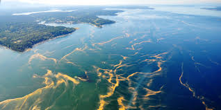
The images of the study area for the year 1986, 2003 and 2022 are also presented in the following Figures 1 to 4.

Figure 1. Landuse classes
Landuse status of the study area for 1986.

Figure 2. Researchers reproduced using Erdas imagine from Landsat Thematic Mapping (2024).
Landuse status of the study area for 2003.

Figure 3. Landuse status of the study area for 2003.
Landuse status of the study area for 2022.

Figure 4. Landuse status of the study area for 2022.
The results of the maps above show a notable spatio-temporal heterogeneity in the rates of gain and loss among the various landuse and land cover categories. This study has therefore revealed the pressure subjected to the study area's natural richness and the mangrove in particular as being significant. The findings showed that the aquatic bodies' coverage was still declining, with (0.047 km2) 0.235% of them in the first 17-year period and (-0.659 km2) 2.194% decrease in the 19-year period, which the overall period has decreased to (-0.612 km2) 1.17% in the last 36-year period (1986–2022). The reasons why water bodies are decreasing are due to their conversion into agricultural areas, filling them up for human settlements, and the construction of bridges and drainage systems to prevent flooding. This causes the bodies of water to shrink, degrade, and dry up. Also, due to human disturbances, many tributaries of the water body have become open drains and lost their self-purification abilities. This result is in line with the result by Sajib et al., (2022) in Delhi, India, where their findings showed a decreasing trend in water bodies with about 5.58 km2 during the period 1989-2000 and again decreasing to 42.84 km2 from 2010-2020. This poses serious environmental issues for agriculture, which include food insecurity, drought, and water availability. Additionally, it has significant implications for the survival of the populations that still depend on irrigation farming and aquaculture. The area occupied by mangrove swamp forest indicated a rapid loss of forest resources, which has severe effects on biodiversity and ecosystem degradation. From 1986 to 2003, the land cover was reduced at a rate of 37.8%, while in the years 2003 to 2022 the study area was reduced by 0.047 km2 and -0.0189 km2 overall of 1986 to 2022 is 2.41%, respectively. The decline in the size of the mangrove swamp forests is a sign of persistent and threatened disturbances brought about by strain on the current ecosystems, which results in a decline in soil nutrients, a fall in resilience and stability, and the loss of agricultural land. This is consistent with a study conducted by Mohammed et al., (2023) on vegetation change in Katsina state, Nigeria, which revealed a considerable loss in forest areas between 2009 and 2019. This resulted from human activities encroaching on the area's native vegetation, which made it susceptible to desertification.
The study also found that builtup/bare land shows a steady increase in the study area over the 36-year' period. This increase is attributed to population growth and urbanization. The results of farming, bush burning, and urban and industrial expansion, among others, led to the reduction of fresh water swamp. This result is also linked to the upsurge in the area built up, showing a significant increase in this land cover. The result showed a steady increase of 12.5% cover in the first 17-year period, followed by a 50.47% cover from 2003 to 2022 and a 33.77% cover in the overall 36 years. This class shows a tremendous expansion in the area of road construction and structures such as schools, churches, administrative units, and buildings. This is similar to the result of the drivers of landuse change. Rural-urban migration, population growth, and housing demand have all contributed to the increase in built-up land area. Areas taken by the government for socioeconomic activities likewise push land owners into new places where they buy land and convert it into buildings, especially for rental purposes, in exchange for income. Also, the results implied that bush fallow and cultivated land increased to produce more crops by increasing farm size and socio-economic activities (road expansion), but it was at the expense of natural forest degradation and severe soil erosion. This corresponds with the findings of Bosire et al., (2022), where built-up expansion occurs due to socioeconomic activities and improved livelihood in the area. In general, this study aligns with the work of Cutis et al., (2021), and their study reported notable changes in land cover, including thickets and dense brush, woods, water bodies, subsistence agriculture, and built-up regions, between 1990 and 2018.
From the findings of the study, it is clear that the activeness and advancement of landuse and land cover has been mostly influenced by the interplay of socio-economic drivers that has exposed the study area to both transformation and modification of lands. This has been confirmed through land cover analysis and socio-economic survey. The study concluded that there is a significant relationship between landuse dynamics in the study area. Conclusively, the results of the study area have been linked with theories of landuse/cover transition, integrated landuse/cover. Through this process, the validity of the theory has been examined for its ability to underpin the explanation of socio-economic drivers of land cover change in the study area.
[Crossref] [Google Scholar] [PubMed]
[Crossref] [Google Scholar] [PubMed]
[Crossref] [Google Scholar] [PubMed]
[Crossref] [Google Scholar] [PubMed]
Select your language of interest to view the total content in your interested language